Pencils, protractors and rulers, oh my…

When you are researching land records in this country there are generally two kinds of property descriptions you will run into ‘metes and bounds’ and ‘rectangular survey’

The latter type is pretty easy to understand, everything is divided into squares or rectangles with specific acreages in wholes, halves, quarters. But metes and bounds is a whole other animal. 
Below is an example of each of property type. The first was owned by GEORGEs (Virginia/West Virginia) and the second was owned by CONNELLYs (Wisconsin):

BEGINNING at a beech and sugar tree on the south bank of McClery’s fork, and running thence
S45 degrees E55 poles to a hickory on a ridge
E344 poles to a white oak on the side of a hill
N100 poles to a black oak on the side of a point
N53 degrees, W180 poles to a stone on a hill near some white oaks
S82 degrees W184 poles to a white oak in a narrows, and thence
S20 degrees, W160 poles to the BEGINNING

and

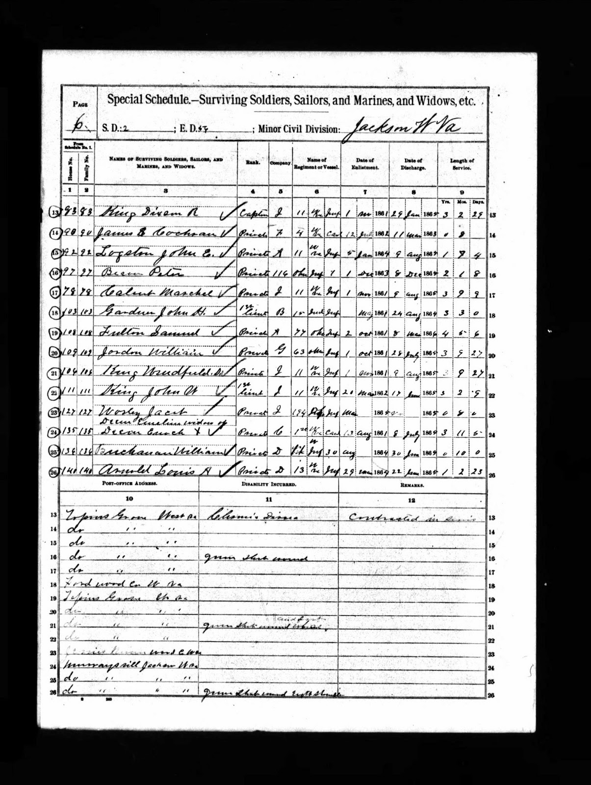
sw1/4 sw1/4  s23  t18  r19 (translated this means – the southwest quarter of the southwest quarter of section 23, township 18, range 19.)

I made the metes and bounds property description easier to read by separating each description, normally you would see it as one long paragraph. You can also see the difference between the two methods in the description of each. The rectangular survey method is much easier to read and figure out.

So while I have understood for many years how to figure out what sections look like on a map. I had never tackled metes and bounds, until a few weeks ago, at which time I decided it was time to learn something new by practicing with my GEORGE family deeds. These deeds are all located in Tyler County, West Virginia.

Here is my first attempt:

This one came out pretty close, the poor quality of my tools affected the outcome.

The second one:

The trick is pretty simple, you need a protractor or something with degrees on it, a pencil, and a ruler. Put a dot on your paper center the dot on your protractor mark the first degree in the proper direction, then measure out the poles or rods. Next. Well, I won’t go into any more detail, after all it is actually something you have to do to understand better and once you learn the procedure, it is pretty easy and fun.

Once you start drawing out these property descriptions you also start finding out where the errors are in the surveyors measurements or the register of deeds copying talents, because over time errors do appear, as can be seen in this property I drew out:

Something is definitely wrong with the deed in the above drawing, now I just have to figure out where the mistake is. The squiggly line on the bottom is in fact a ‘meander’, this line actually follows a creek.

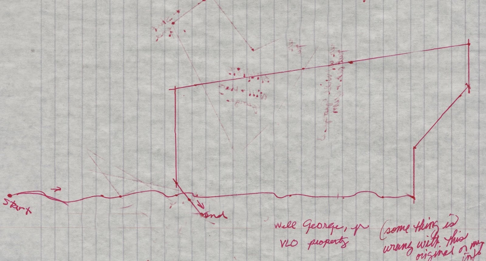
Here is another example of a bad deed. The numbers were very hard to read on this one and I believe the clerk writing it out made a couple of mistakes. I have drawn four versions of what the property looks like in this one drawing, none of them line up properly. I was going by what the numbers could be in the deed.

Guess I have some more work to do in Salt Lake City.

More union soldiers, a wedding and a death…

I am back from my trip to Salt Lake City. Who would think that a weeks vacation could be that exhausting.

I spent many an hour looking bleary eyed at microfilm. All in an effort to find something new about our  ancestors. I am happy to say that I did find a tidbit or two.

Firstly, until just this last week I had no idea when Jennie/Jannett Smith Rosa Lavelley died. I did know it was after 1870 and before 1898 (according to her ex-husband, Abram Rosa’s, pension). But this week I found a quit claim deed filed in Berrien County, Michigan labeled ‘Jannett Rosa, by heirs’ to Michael Smith [her brother]. The incriminating bit of information in that index entry was the ‘by heirs’ part. The deed was filed in 1877. Okay, it didn’t give me the exact date of death, but now I know that Jennie died between 1870 and 1877, a much shorter date range. Who knows, maybe a bit of digging in my own backyard will turn up more on that issue, after all she lived in Oconto.

Secondly, the Buchanan family has been researched by others, but some of what they have put out there is wrong. I now know that Margaret and William Buchanan died in Jackson County, West Virginia. Margaret in 1883 and William in 1891. I found their death records online. Easy peasy. Well, after Margaret died, William must have been feeling a bit lonely because he married again in 1884 to an Emily Duke. How do I know this, land records. William and Emily are selling land together to family, etc. in Jackson County in the 1880s. It took me a while to realize that the name of his wife was Emily in the deeds as I am mostly just photographing records and looking at them later. I am glad I did though. Now I can add Emily to the records. I even confirmed the marriage by finding their certificate online.

Thirdly, After learning about Emily, I dug around on Ancestry to see if there was something I missed about William Buchanan in their online records. William is the first Shepard side ancestor I have found to have been an actual soldier in the Civil War. He joined the Union’s 17th Regiment, Company D, Infantry. He was only in the war for about a year, the same as F. W. John. He appears to have survived the war without any incidents. But, he didn’t live long enough to file a pension having died in 1891. Emily his wife died by 1900, as we know from the land records. When she died the land she inherited from William, had to pass on to his children: Jane, Ebenezer, Rebecca and Sarah.

All in all I have had affirmed in my mind the importance of land records in doing one’s research. It can lead you to finding all kinds of little gems.

This is the page from the 1890 Veteran’s Schedule showing William Buchanan.